
Key facts
- The airport record shows 2.13 in. of rain at Hartsfield-Jackson on September 21, 2009 (calculated by Atlanta Water Damage & Mold on November 18, 2026). ACIS daily record, Atlanta Hartsfield-Jackson International Airport
- Out of 35,869 days with a rain reading since 1928, that total ranks 227th; among the 2,970 September days alone it ranks 28th (calculated by Atlanta Water Damage & Mold on November 18, 2026). ACIS daily record, Atlanta Hartsfield-Jackson International Airport
- One day brought 56% of the 3.82 in. a normal September gets at the airport, by the 1991-2020 normals (calculated by Atlanta Water Damage & Mold on November 18, 2026). ACIS daily record, Atlanta Hartsfield-Jackson International Airport
- Counting the wetter day beside it, 2.74 in. fell in two days (calculated by Atlanta Water Damage & Mold on November 18, 2026). ACIS daily record, Atlanta Hartsfield-Jackson International Airport
Daily rain, a week either side
Daily rain at Atlanta's airport for the seven days before and after September 21, 2009; the amber bar is the report day.
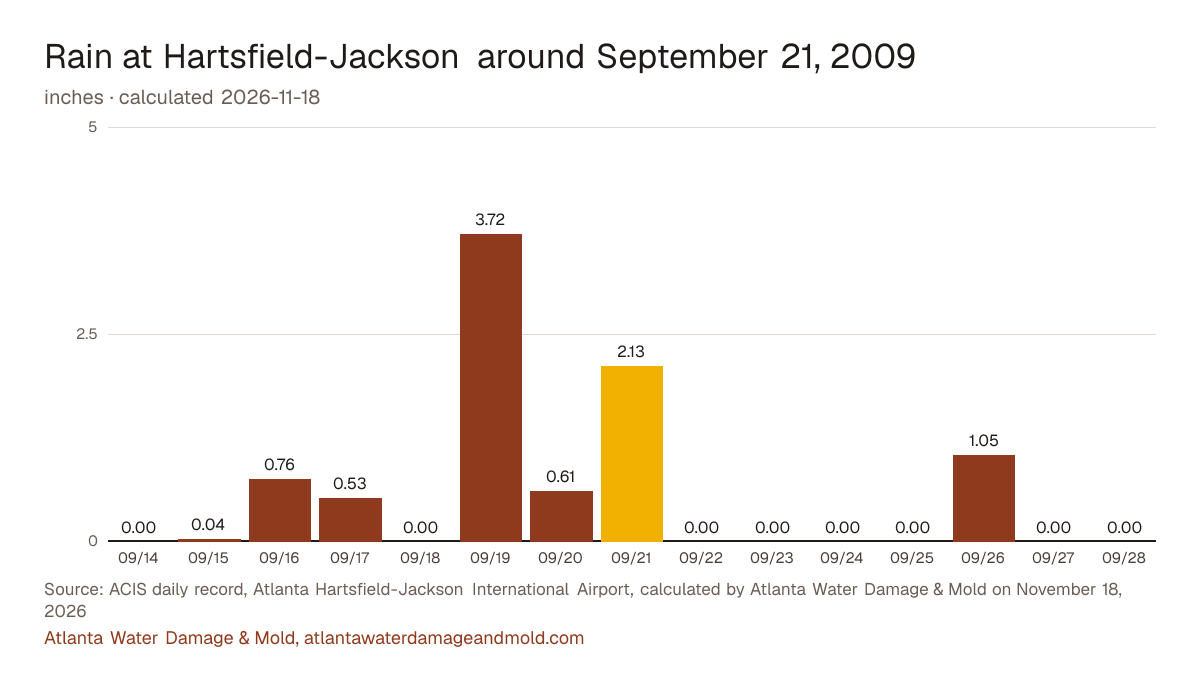
Show the daily numbers
| Day | Rain | Low |
|---|---|---|
| September 14, 2009 | 0.00 in. | 72°F |
| September 15, 2009 | 0.04 in. | 70°F |
| September 16, 2009 | 0.76 in. | 70°F |
| September 17, 2009 | 0.53 in. | 68°F |
| September 18, 2009 | 0.00 in. | 68°F |
| September 19, 2009 | 3.72 in. | 69°F |
| September 20, 2009 | 0.61 in. | 68°F |
| September 21, 2009 | 2.13 in. | 70°F |
| September 22, 2009 | 0.00 in. | 68°F |
| September 23, 2009 | 0.00 in. | 68°F |
| September 24, 2009 | 0.00 in. | 70°F |
| September 25, 2009 | 0.00 in. | 72°F |
| September 26, 2009 | 1.05 in. | 65°F |
| September 27, 2009 | 0.00 in. | 64°F |
| September 28, 2009 | 0.00 in. | 61°F |
Peachtree Creek crested at 23.7 feet
The National Weather Service lists a crest of 23.7 ft on September 22, 2009 for Peachtree Creek at Atlanta (Northside Drive), against a flood stage of 17 ft. At 22 feet, the NWS impact statement for the gauge reads: Homes, businesses and apartments along the creek take a few feet of water and many evacuations are needed.
Source: NWS: Peachtree Creek at Atlanta (AANG1), flood categories, impacts and crest history.
Flood claims and federal declarations
NFIP flood claims in the 25 ZIP codes on this site with a date of loss of September 21, 2009: 474. From September 18, 2009 to September 24, 2009: 555.
- DR-1858: Severe Storms and Flooding, incident period September 18, 2009 to October 8, 2009.
Sources: FEMA OpenFEMA NFIP Redacted Claims v3 (date of loss) and Disaster Declarations Summaries v2, calculated by Atlanta Water Damage & Mold on November 18, 2026. Claims for each ZIP are on the Atlanta flood map by ZIP. This product uses the Federal Emergency Management Agency's OpenFEMA API, but is not endorsed by FEMA. The Federal Government or FEMA cannot vouch for the data or analyses derived from these data after the data have been retrieved from the Agency's website(s).
Things to look at in an Atlanta house after a day like this
- Open the crawl space door or walk the basement: standing water, wet insulation or a damp smell under the floor shows up a day or two after a soaking rain.
- A floor drain or tub that backed up during the storm means the sewer was surcharged. On the city side, Watershed Management takes the call at 404-546-0311.
- Creek or yard water that came inside counts as Category 3. Keep children and pets out of it and photograph the high-water line.
What the official sources say
Rain began across north Georgia on Sept. 15, 2009, and the airport logged 3.70 inches between daybreak and 8 p.m. on a single day of the event, more than twice the old record for that date, according to the National Weather Service. Its event page lists Peachtree Creek at Atlanta cresting at 23.89 feet late on Sept. 21, against a flood stage of 17 feet, and says about 20,000 homes, businesses and other buildings in the region took major damage.
Sources: National Weather Service Peachtree City: Epic Floods of 2009; NWS: Peachtree Creek at Atlanta (AANG1), crest history
The five nearest days in the record
| Day | Rain |
|---|---|
| October 10, 2026 | 2.13 in. |
| October 6, 2013 | 2.13 in. |
| March 7, 1996 | 2.13 in. |
| July 3, 1989 | 2.13 in. |
| February 13, 1966 | 2.13 in. |
Sources: ACIS daily record for the Atlanta Hartsfield-Jackson International Airport (USW00013874), with daily readings from September 1, 1928; NCEI 1991-2020 normals via ACIS; FEMA OpenFEMA. The report rule and the method are on the sources and methods page.
Cite this page: “Atlanta 2009 flood: 2.13 in. of rain, September 21, 2009.” Atlanta Water Damage & Mold, https://atlantawaterdamageandmold.com/atlanta-flooding/2009-09-21/. Updated November 18, 2026.